
Imagine waking up one morning to find that the water flowing from your tap has stopped completely. It sounds alarming, doesn’t it?
Water conflict risk maps are tools that can help prevent this scenario from becoming a reality. They highlight regions where water scarcity could lead to disputes, helping you understand the potential risks in your area. Whether you’re a concerned citizen or someone working in policy or planning, these maps can guide you in making informed decisions about water usage and conservation.
By knowing where conflicts might arise, you can take proactive steps to ensure a stable future for your community’s water supply. This knowledge is not just empowering—it’s crucial for safeguarding your access to one of life’s most essential resources. Keep reading to discover how water conflict risk maps work and how they can be a game-changer for you and your community.
Global Water Scarcity
Water is essential for life. Yet, many regions face water scarcity. This issue affects millions worldwide. As populations grow, the demand for water increases. Limited resources make this challenge more severe.
Rising Demand And Limited Supply
Global population growth is rapid. More people means more water needed. Agricultural and industrial activities need water too. Freshwater sources are under pressure. Supply cannot keep up with demand. Water scarcity leads to conflicts over resources.
Impact Of Climate Change On Water Resources
Climate change affects water availability. Droughts are more frequent and severe. Rainfall patterns shift unpredictably. Glaciers, crucial water sources, melt faster. These changes reduce water supplies. Communities struggle to adapt. Scarcity can lead to regional instability.
Credit: hcss.nl
Understanding Water Conflict
Water Conflict Risk Maps help identify areas likely to face water disputes. They show regions with potential tension over water resources. This tool aids in planning and preventing conflicts.
Understanding Water Conflict Water is essential for life, yet its scarcity often leads to disputes. Imagine waking up one day to find your local river has dried up, and neighboring communities are battling over the remaining water resources. This unsettling scenario is a reality for many, highlighting the importance of understanding water conflict. As populations grow and climate change intensifies, the risk of water disputes increases. You might be wondering how these conflicts arise and what can be done to prevent them.Factors Contributing To Water Disputes
Several factors contribute to water disputes. Limited water availability is a significant issue, exacerbated by climate change and inconsistent rainfall patterns. Economic factors also play a role. Industries often consume large amounts of water, sometimes at the expense of local communities. Political tensions can escalate water disputes. Countries sharing water sources may disagree on usage rights, leading to conflicts.Historical Examples Of Water Conflicts
Throughout history, there have been numerous water conflicts. One notable example is the dispute over the Nile River between Egypt and Ethiopia, which has persisted for decades. In the Middle East, the Jordan River has been a source of contention, affecting relations between Israel, Palestine, and Jordan. Closer to home, you might recall the California water wars, where agricultural interests clashed with urban water demands. These examples demonstrate that water conflicts can occur at both international and local levels. Can these historical lessons guide us in resolving future disputes?Role Of Risk Maps
Risk maps pinpoint areas where water conflicts may arise due to scarcity or mismanagement. These maps help governments and communities understand potential threats. By visualizing risk, stakeholders can plan better and avoid disputes.
Water conflict risk maps play a crucial role in understanding and addressing potential water-related conflicts around the world. These maps provide valuable insights into areas where water resources are scarce or mismanaged, helping policymakers, communities, and organizations plan and make informed decisions. By visualizing the geographical distribution of water risks, stakeholders can prioritize interventions and allocate resources more effectively.Purpose And Function Of Risk Maps
Risk maps serve as essential tools for identifying areas prone to water conflicts. They highlight regions with high water demand and limited supply, often due to environmental, social, or political factors. By clearly illustrating these hotspots, risk maps help you understand the dynamics of water scarcity and its potential to cause disputes. These maps are not just static images but dynamic tools that guide decision-making. They allow you to visualize trends over time, showing how water availability might change with population growth or climate change. This forward-looking perspective is crucial for developing strategies to prevent conflicts before they arise.Technological Advances In Mapping
Technological advancements have significantly improved the accuracy and usability of water conflict risk maps. Satellite imagery, geographic information systems (GIS), and machine learning are just a few technologies that enhance our ability to map water resources. These tools provide real-time data, enabling you to track changes in water availability and use more efficiently. Imagine planning a water conservation project with outdated maps. It’s like navigating a city with a decade-old street guide. Modern technology ensures maps are updated, offering the latest insights into water risks. This immediacy empowers communities and governments to act swiftly and decisively. Technology also democratizes access to these maps. Online platforms make it easier for you to view and interact with risk maps, regardless of your technical expertise. This accessibility ensures that even local communities can participate in water management discussions, fostering more inclusive and effective solutions. Have you considered how risk maps could influence decisions in your community? What steps can you take to ensure these tools are used effectively? By actively engaging with this technology, you can contribute to sustainable water management and conflict prevention.
Credit: www.researchgate.net
Analyzing Risk Areas
Water Conflict Risk Maps help identify areas where disputes over water resources are likely. These maps show potential conflict zones by analyzing factors like water scarcity, population density, and political tensions. They provide valuable insights for planning and managing water resources effectively.
Water Conflict Risk Maps serve as crucial tools in understanding where water-related conflicts are most likely to occur. They help identify regions with high risk and provide insights into the underlying factors contributing to these tensions. Analyzing risk areas enables policymakers, researchers, and communities to strategize and take proactive measures, potentially mitigating conflicts before they escalate. But what makes certain areas more vulnerable to such conflicts? Let’s delve into the details.Regions Most Vulnerable To Water Conflicts
Certain regions are more prone to water conflicts due to a combination of geographical, political, and environmental factors. Areas with scarce water resources, such as arid and semi-arid regions, are often at higher risk. These locations may experience increased competition for limited water supplies, especially during droughts or times of environmental stress. Political instability can also exacerbate water conflicts. Regions with ongoing territorial disputes or weak governance may struggle to manage shared water resources effectively. Without clear agreements or regulations, tensions can rise, leading to conflicts. Have you considered how political stability impacts water resource management in your region?Socioeconomic Impacts On Affected Areas
Water conflicts have profound socioeconomic impacts on affected areas. Communities facing water scarcity often experience disruptions to agriculture, their primary livelihood. This can lead to food insecurity and economic instability, affecting the overall quality of life. Access to clean water is a fundamental human need, and its scarcity can lead to health issues and reduced productivity. Education and development opportunities may be hindered as communities focus on immediate survival rather than long-term growth. Think about how your daily life would change if water became scarce in your community. Addressing these challenges requires a multifaceted approach, integrating technology, community engagement, and policy reform. By understanding the risk areas, you can contribute to creating sustainable solutions that ensure water security for all. How can you play a role in advocating for better water management practices?Case Studies
Water conflicts often arise in regions with scarce resources. Understanding these conflicts helps in planning better solutions. Let’s explore some key areas facing water tensions. Learn how water conflict maps shed light on these issues.
Middle East Water Tensions
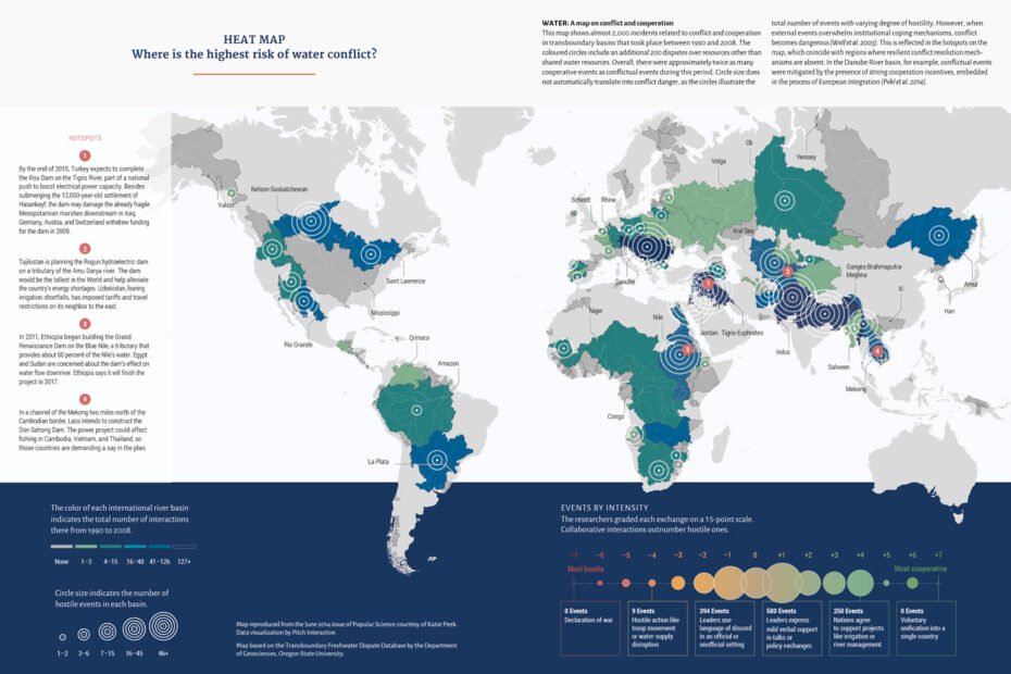
The Middle East faces severe water challenges. Major rivers like the Tigris and Euphrates are shared by multiple countries. This sharing leads to disputes over water rights. For instance, Turkey, Syria, and Iraq often clash over water usage. Dams built upstream reduce water flow downstream. These actions create tension among nations. Water scarcity worsens the situation. Climate change further complicates these issues. Solutions need cooperation among countries. Water conflict maps help identify high-risk areas. They guide policymakers in conflict resolution.
South Asia’s Transboundary Water Issues
South Asia deals with complex water-sharing challenges. The Ganges, Brahmaputra, and Indus rivers flow across national borders. Countries like India, Bangladesh, and Pakistan depend on these rivers. Disputes arise over water allocation and usage. Monsoon patterns make water supply unpredictable. This unpredictability heightens tensions. The Indus Waters Treaty is one attempt to manage these disputes. It outlines water-sharing rules between India and Pakistan. Yet, disagreements persist. Water conflict maps highlight vulnerable regions. They assist governments in managing water resources effectively.
Strategies For Conflict Prevention
Water Conflict Risk Maps help identify potential areas of dispute over water resources. These maps guide strategies for conflict prevention by providing insights into vulnerable regions. They serve as essential tools for governments and organizations to prioritize interventions and promote cooperation.
Water conflict risk maps are essential tools in identifying potential areas of tension over water resources. They highlight regions where water scarcity might lead to disputes. But how can we prevent these conflicts from escalating? You can play a vital role in fostering peace and cooperation through effective strategies. Let’s dive into some actionable measures for conflict prevention.International Cooperation And Treaties
Building bridges between countries over shared water resources can significantly reduce conflict risks. Treaties and agreements are not just about legal paperwork. They represent mutual respect and understanding. Consider the Indus Waters Treaty between India and Pakistan. Despite historical tensions, this treaty has been a cornerstone for water cooperation. International bodies and organizations often mediate such agreements, ensuring fairness and transparency. Have you ever thought about the power of dialogue? Encouraging open communication between nations can transform potential conflicts into partnerships.Sustainable Water Management Practices
Sustainability is not just a buzzword; it’s a necessity. Implementing sustainable water management practices can preserve resources for future generations. Think about rainwater harvesting in urban areas. It’s a simple yet effective way to store and use rainwater sustainably. This practice reduces dependency on natural water bodies, alleviating pressure and potential conflicts. Encouraging local communities to engage in water conservation can also make a difference. Education and awareness campaigns can empower individuals to take responsibility. Every drop saved is a step towards peace. What sustainable practices can you implement in your community? Can collective efforts make a difference in your region? The strategies for conflict prevention in water management are not just about policies. They’re about creating a culture of cooperation and responsibility. By actively engaging in these strategies, you can contribute to a more harmonious world.Future Of Water Conflict Maps
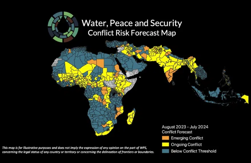
The future of water conflict maps is promising. These tools offer critical insights into potential water-related disputes. They help predict where conflicts might arise. Water conflict maps are vital for managing resources. They help plan and implement solutions before problems escalate. As technology advances, these maps become more precise and informative.
Evolving Technologies And Data Collection
New technologies enhance water conflict maps. Satellite imagery offers precise data. Sensors collect real-time water information. Machine learning analyzes patterns quickly. These tools improve prediction accuracy. They provide a clearer picture of water resources. Advanced software helps visualize complex data. This makes understanding easier for everyone.
Potential For Policy Influence And Decision Making
Water conflict maps can shape policies. They provide data for decision-makers. Policymakers use these maps to allocate resources. They help prioritize areas needing urgent attention. By highlighting risks, maps guide effective strategies. Decision-makers can create policies for sustainable water use. This ensures fair distribution and reduces conflict risks.

Credit: www.newsecuritybeat.org
Frequently Asked Questions
What Are Water Conflict Risk Maps?
Water conflict risk maps visualize areas prone to disputes over water resources. They highlight regions with potential conflicts due to scarcity, management issues, or geopolitical tensions. These maps help policymakers prioritize interventions and promote sustainable water management practices.
How Are Water Risk Maps Created?
Water risk maps are created using data analytics and geographic information systems. They combine hydrological data, socio-economic factors, and geopolitical information. The analysis identifies regions with high conflict potential, aiding in proactive resource management and conflict prevention.
Why Are Water Conflict Maps Important?
Water conflict maps are crucial for sustainable resource management. They help identify regions at risk of disputes, enabling targeted interventions. Policymakers use these maps to allocate resources effectively, promote cooperation, and develop strategies to prevent conflicts over water.
Who Uses Water Risk Maps?
Water risk maps are used by policymakers, researchers, and environmental organizations. They guide decision-making in water resource management. These stakeholders utilize maps to address potential conflicts and enhance cooperation in water-scarce regions.
Conclusion
Water conflict risk maps are essential tools for global peace. They help identify potential conflict zones. Leaders can act before tensions rise. These maps guide resource management. They promote cooperation among nations. Understanding water conflicts can save lives. Access to clean water remains crucial.
These maps support sustainable development goals. Communities need to work together. Water is a shared resource. Protecting it ensures a better future. With effective use, water conflict maps can lead to harmony. Let’s prioritize water security for all.